

Where has the “vision” gone in Docklands?

Melbourne Maritime Heritage Network (MMHN) often bemoans the fact that Melbourne has “amnesia” about the significance of its rich maritime heritage. We wonder – is a similar “amnesia” taking hold in relation to Docklands?
Is all that is unique about the precinct now simply being ignored by Development Victoria (DV) – the agency responsible for implementing the ‘90s optimistic “vision” for Docklands?
It seems to have completely vanished – or perhaps the most appropriate phrase – been vanquished. What we’ve seen (or have not seen) in Docklands recently is in depressing contrast to the plethora of visionary plans for the area, which emerged in the 19th and early 20th centuries.
The “vision” for Docklands back then was about ambition, opportunity and prosperity for Victoria literally flowing through the wharves and waterways of our critically important maritime trade sector.
In stark contrast, “vision” in the late 20th century as we see in Docklands today is limited to prosaic real estate development and the often-baffling sculptures dotted about Docklands streets. Any coherent Docklands Precinct Plan presenting any “vision” is still to emerge. Has the political will to complete the Docklands project now waned? We wait and wonder.
Wharves matter in Docklands “vision”
The Docklands community will be more aware than most waterside communities, that wharves should be understood as critical community assets.
Just like open space and pathways are community assets in Docklands, its wharves form the interface between the land and the waterways.
Sad but true for Docklands, this connection has been ignored and degraded for decades. Highly valued and repurposed elsewhere in port cities around the world, DV apparently saw no value in preserving maritime heritage infrastructure and wharves here.
All around this unique waterways precinct, DV has demonstrated little “vision” for optimising the value of wharf infrastructure they are tasked with managing, leaving aside the incremental demolition of the western end of Central Pier, which was left crumbling for years in Victoria Harbour. This was followed by the ongoing debacle of Central Pier.
Questions arise – despite the acute shortage of open space in the precinct, why has DV permitted MAB to fence off a large area of NewQuay from Wattle Rd to the Bolte Bridge for years and not instead required the re-instatement of the long stretch wharf adjacent to their development site? This would provide the community access to a substantial waterside linear park.
It was not always so.
Delving into the archives of the Public Records Office (PROV) and University of Melbourne, Sebastian Gurciullo, a professional archivist, curator, editor and writer, has researched maps and plans from PROV’s collection, to explore the myriad of plans and decisions associated with the Yarra River and the developing Port of Melbourne from the 1850s to 1973. These plans reveal ambition and optimism, a depressing contrast to the absence of any “vision” for the Docklands community today.
The question arises – will we look back at Docklands in 2024 as yet another in the long list of fanciful schemes which “never eventuated, either because they were too fanciful or because circumstances changed, rendering them unfeasible, undesirable or otherwise invalid”.
For the sake of those making their lives in Docklands, MMHN sincerely hopes not. We hope “visioning” Docklands returns soon and that it includes such essentials as open space, permanent activation, wharf repair, and a secondary school before the primary school reaches capacity. Not rocket science, is it? •
Captions:
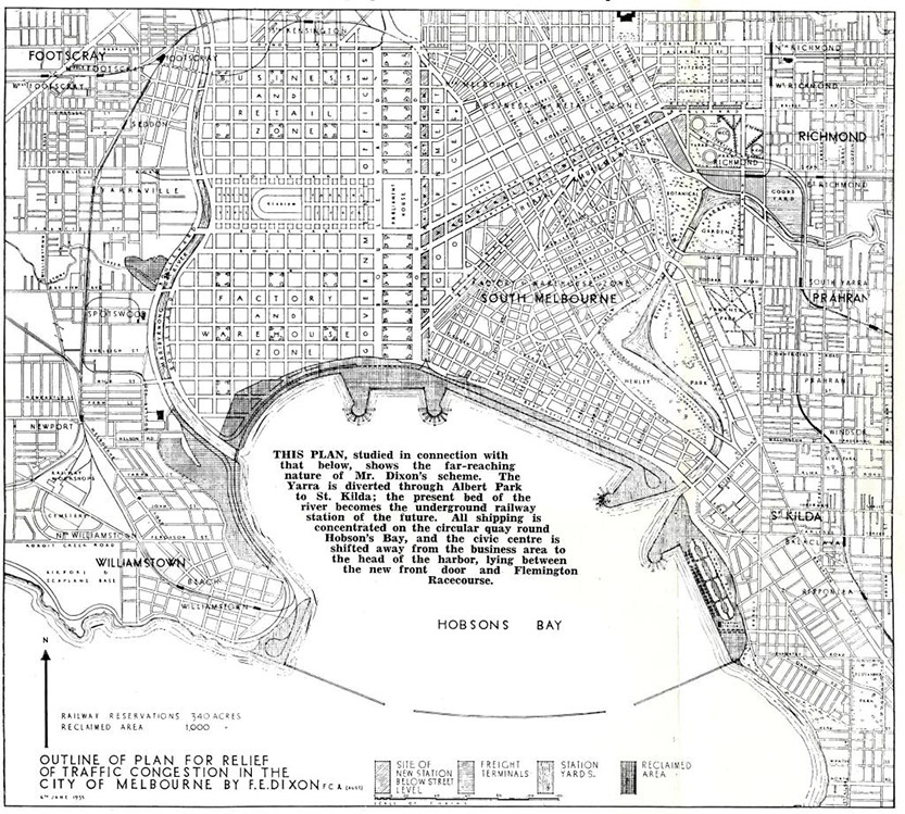
Figure 10: Outline of plan for relief of traffic congestion in the City of Melbourne by FE Dixon, 1939, PROV, VPRS 10217/P0 Minister’s General Correspondence Files, 26–728 (Unit 27), 41/161, excerpt from ‘Planning Melbourne for prosperity’. The caption within the centre of the plan makes reference to the 1929 "Plan of general development" (see Figure 7) which was included for comparison.
Figure 6: John Millar’s elaborate and highly ornate proposal for a westward expansion of the city, including botanical gardens and lake, also featuring a direct channel to Hobsons Bay, PROV, VPRS 8168/P2, MCS62; PORT OF MELBOURNE.
Related Articles

City of Melbourne council: the good and the not so good
Let’s start with the good …
Read More
Shipping Control Tower: questions remain
Until now this significant maritime infrastructure asset, the responsibility of state authority Development Victoria (DV), continues to loom as a degraded bastion of failed vision like the Wheel, Harbour Esplanade and Central Pier.
Read More
New Docklands Station under Metro 2 plans, but what about Yarra’s Edge?

Central Pier afloat? Brooke Street Pier engineer to visit Docklands

 Download the Latest Edition